5 Best Hiking Trips in Catalonia

Pyrenees | Photo by Juan Goyache on Unsplash
The more you discover Catalonia, the more you surrender its breathtaking nature and scenic views. If you are looking for an active and relaxing experience in the region, here is a list for you!
GR’s: a hiker’s paradise
“GR” literally translates to “grand route or gran recorrido in Spanish. If you like to hike, there are hundreds of GR’s to choose from. They are not only in Spain, but throughout most of Europe. Before we get into more detail, it’s important to understand that most hiking trails in Europe are organized and categorized according to the distances they cover, and are identified by a standardized, yet simple, system of signage.

- Trails longer than 50km (31 miles) are classified as grand routes and are marked in red and white;
- Between 10-50 km (6-31 miles) in distance are shorter routes, marked in yellow and white;
- Under 10km (6 miles) in distance are local routes and are marked in green and white.
These European-wide standardized markings are located along each route and can be seen painted on rocks, trees, posts or, as more formal signage, like freestanding signs. Such markings are designed to guide hikers and to make sure they find their way: the two parallel lines are placed so that they indicate the actual direction of the route. In other words, they run parallel with the hiking paths. In those cases where there are several paths that cross at an intersection, the same stripes will mark with an X the wrong path. Likewise, when a path shifts direction, the same stripes will also indicate that new direction.
These hiking routes can be found throughout Europe, mostly in Germany, France, Belgium, The Netherlands, and of course, Spain. Some actually connect different countries and pass through places of cultural and/or historical interest, connecting towns and villages along a vast network of trails, the most famous of them being the Camino de Santiago.
1) Rupit Hike: Salt de Sallent

This challenging 6km (3.7 mile) hike follows through the mountainous, forested terrain that surrounds the tiny, picturesque village of Rupit, a medieval wonder located only 1.5 hours from Barcelona, with views of the Sierra de Cabrera. A day trip to Rupit itself is worth the effort, but we actually suggest that you start your 2.5-hour hiking adventure here; we’ve outlined a convenient, circular route to help you enjoy one of the most picturesque hikes we know.
How to get there?
From Barcelona by car, follow signs to the highways C-33 and C-17, toward Vic to the north. Exit to route C-25 and then go to C-153, toward Roda de Ter, which will eventually bring you to Rupit.
To start your hike, cross into the village center using the hanging bridge, turn right toward the church and follow the street “Carrer de l’Esglèsia”. Take your first left after the church, which will take you down a narrow path, winding downhill. By now you’ve left the town. Look for signs to your first destination, the small chapel called Santa Magdalena, and from there, continue following signs to “Mirador del Bassis” and then “Salt de Sallent”. After visiting the latter, just follow the signs back to Rupit.
If this sounds all too daunting, please feel free to contact us. We’d be more than happy to guide you on our Medieval Mountain Village and Panoramic Trails day trip. After the hike, you’ll be rewarded with a traditional Catalonian feast that’s an experience in itself!
What it has to offer?
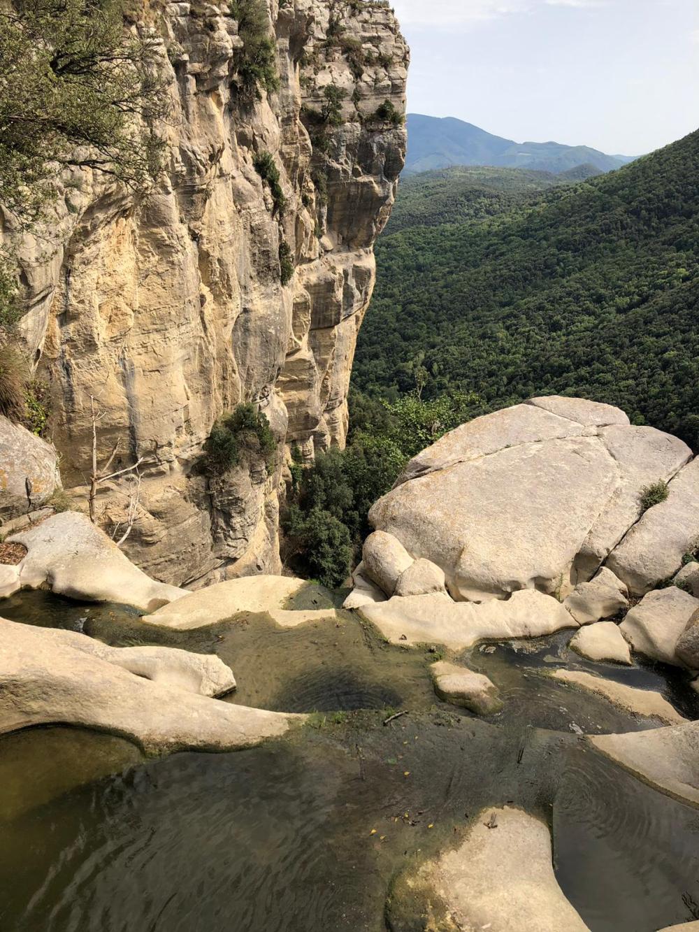
Located in what is considered the pre-Pyrenees, with views of the mountainous district of Collsacabra. This hike has it all: amazing views, rivers, meandering streams, cool forests where ferns and rocks take shade from the sun, a medieval chapel and church, tombs dating from the Visigoth era, and the waterfall with the longest drop in Catalonia at around 100m (330 ft).
After the hike, if you still have energy, walk the narrow, stone streets of Rupit, with its Baroque church, get a taste of the local cuisine, including its cured meats, cheeses, the famous ratafia liqueur or the amazing local pastries called “coques” some with chocolate, others with cream or anisette.
If you’re staying in the area, don’t miss towns like Tavertet or Santa Pau, the short hike to the Foradada de Cantonigròs or the famed forest, Fageda d’en Jorda, located in the Garrotxa Natural Park.
2) Camí de Ronda
If we had to choose one word to describe the Camí de Ronda, it would be “magical”. The hike featured here is actually part of the GR92, a trail running through the entire coast of Catalonia, from Portbou in the north, to Ulldecona, 560km to the south. The 6km (3.7 mile) section of our hike is called colloquially, the Camino de Ronda, and it is located at the heart of the Costa Brava, one of the most breathtaking coasts in Spain. The trail was used centuries ago to connect the many coastal towns with fortresses and lighthouses, and also served as a lookout for potential threats from the sea. As you pass the beaches accessible only by foot, you’ll find the vast, pristine waters of the Mediterranean below on the one side, and forests of pine, oak and cork trees on the other.

Camí De Ronda Pyrenees | Photo by Isabelle Berga
How to get there?
This hike takes place in the heart of the Costa Brava, an area that extends north from the town of Blanes, up to Portbou on the French border. Our hike starts at Platja Castell, which is only 1.5 hours from Barcelona by car. Our Cliffs & Coves: Hiking the Costa Brava day trip includes a 3-hour guided hike, snacks and water, the option to swim/snorkel, private transportation to and from Barcelona, and an amazing 3-course seafront lunch in the white-washed village of Calella de Palafrugell.
What it has to offer?
There are lots of challenging hikes out there that offer magnificent views, but none combines as many amazing features as the Camino de Ronda, dotted with unique beaches and coves. The trail starts at Platja Castell, where the ruins of the Iberian settlement of the same name are located, then follows the rocky coast of the Costa Brava and includes a few challenging sections that run steep inclines; you’ll encounter scents of lavender and rosemary, when the sun hits, which happens 300 days a year.
You’ll walk through forests of pine, oak and cork, and you’ll enjoy several secluded beaches, each with its own features, only accessible by footpaths. Other activities include kayaking, cliff jumping, and snorkeling, which make the hike an interesting activity. If you want to experience the quintessential Costa Brava landscape, this is the trail for you.
If there’s time, it’s always great to pay a visit to the Botanical Gardens at Cap Roig or the Sant Sebastián lighthouse, the first located right on the trail, the latter only a few kilometers away.
The Camino de Ronda’s relative proximity to many attractive coastal towns such as Begur, Sa Tuna or Tamariu, make it a perfect full-day excursion if you’re using any of these places as a base for your stay.
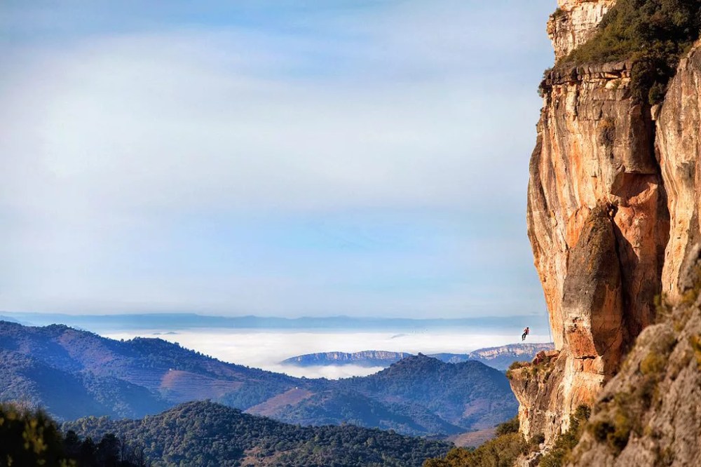
3) Siurana
Siurana is one of the hidden gems of walking tourism in Catalonia and features a charming medieval village on top of the mountain. There are exciting outdoor activities such as trekking, kayaking and wine tasting, along with countless legends and history of conquest. This small village is strategically located 730 meters high and surrounded by a beautiful wild landscape of limestone cliffs and green valleys in the northeast of the Priorat region. It overlooks the valley of the river Siurana, between the Montsant Massif to the west and the Prades Mountains to the east, within the municipal area of Cornudella de Montsant.
Siurana | Photo by Piotr Deska
How to get there?
To get to Siurana from Reus take the N-420 to Les Borges del Camp and then the C-242 to Cornudella de Montsant. After Cornudella, carry on towards Ulldemolins. Soon after leaving the village you come to the turn-off to Siurana.
A fantastic walking option is to try the old path up to Siurana from Cornudella de Montsant, recently restored as part of the Priorat footpath network. For this, a good recommendation is to contact a local guide at Cornudella: they not only know the way to perfection, but also are very well-versed in the history of the region and the characteristics of the surrounding nature.
What it has to offer?
Siurana offers a stunning view from the rock known as La Trona and the climbing routes in this area are world-famous. This is due to the abundance of excellent climbs up to grade 9b, making Siurana one of the world’s best climbing destinations.
The town boasts two holiday cottages, a hotel-restaurant, a restaurant, a mountain refuge owned by the Centre Excursionista de Catalunya, a campsite and climbing activity center and a local product shop.
Sites not to be missed include the church of Santa Maria, a well-preserved building from the Romanesque period, between the 12th and 13th centuries, and the remains of the Arab castle, a military establishment built around the 9th century as a center to control the territory. Additionally, the Salt de la Reina Mora is a section of cliff named after a Moorish queen who, according to legend, preferred to cast herself off the cliff on her horse rather than surrender into enemy hands.
4) Barcelona’s Pyrenees: Queralbs, Coma de Vaca and Vall de Nuria
Less than a 2-hour drive from Barcelona, there is the millenary stone village of Queralbs. When visiting this village, which has been built into the walls of the Pyrenees Mountains since the 10th century. It’s like stepping into a fairy tale, and it is well worth the drive. This is the perfect leaping-off point for an amazing two-day adventure through the gorgeous mountain trails, rivers, forest, waterfalls and ridges with astonishing views over the surrounding valleys. This Pyrenees hike could be one of the coolest things you will ever do!

Queralbs, Coma de Vaca and Vall de Nuria | Photo by fotoshikes.com
How to get there?
Getting to Queralbs from Barcelona by car is a relatively easy and short drive. If you follow the highway C-17 toward Ripoll – whose famous Benedectine monastery built in Romanesque style is also worth visiting – and then on the beautiful, winding N-260, alongside the river Freser, until you arrive at the end of the road. It’s less than two hours in total.
If you would prefer to use public transport, there is a train (several times daily) from Barcelona – Sants train station to the town Ribes de Freser. From there, wait for the rack railway train to Queralbs. You’ll need about four hours in total.
What it has to offer?
It’s about the pure essence of the Pyrenees…the trail from Queralbs to the mountain refuge of Coma de Vaca will take you through a spectacular natural environment: forest, river, waterfalls, wooden and stone bridges, impressive rocky walls and canyons. After about three hours, the cozy refuge Coma de Vaca will come into view and will be a very welcomed sight! From the refuge, there are several short excursions that you can take to amazing viewpoints, such as La Trona de Guardiola.
The simple, yet comfortable, refuge will allow you to rest, eat your own food or enjoy the dinner they offer, followed by some relaxing time in the common area, until the lights-out. It’s good to go to sleep early so that you can be hiking at dawn the next day. During those first hours of daybreak, you’ll more easily see the local fauna: ibexes, chamois, eagles, and the iconic Quebrantahuesos, or Bone-Breaker, the spectacular, and nowadays rare, bearded vulture.
On day two, the hike along the Camí dels Enginyers is longer and a bit more strenuous, but absolutely fantastic: three hours of ups and downs, dramatic cliffs, mind-blowing views and narrow passages…it’s all in there! The final stretch before arriving at the lake of the popular Vall de Nuria is a gentle and green downhill. After swimming in the lake, enjoying a lunch at the hotel restaurant or simply a picnic in the grass, it’s time to descend back to Queralbs. You can hike downhill for about two more hours, or choose the rack railway train. Both options will grant you further memorable views of this amazing mountain region.
Level of Difficulty:
The hike does not present specific technical difficulties and the trails, except for a few points, are fairly well-indicated. However, keep in mind that this is a mountain experience: it is important to have a decent level of physical condition, the right equipment and a good amount of information about the weather, local geography and logistic organization. With our customized experiences, we can take care of all the necessary aspects for granting you an unforgettable hiking trip. In total safety and making the most out of your time.
5) Reach for the summit of El Pedraforca
One of the most well-known mountains in the region of Catalonia is the Pedraforca. This Pyrenees hike is surrounded by spectacular nature, plus the climb to the top is not a complicated one, though impressive and generously filled with amazing views.
How to get there?
It is not complicated to arrive at the Pedraforca by car, and there are even some good bus services that will take you there at a very good price.
What is has to offer?
The charm of this mountain comes with its peculiar-shaped summit, which has given it the nickname of Els Pollegons or The Pikes among the locals. The mountain itself is quite a sight, but the natural paradise surrounding it is truly special. This wooded mountain is a one time Pyrenees hiking experience that is easy to enjoy and will definitely make for a memorable day trip in Catalonia, Spain. Another thing that is great about El Pedraforca is that it offers many hiking routes with various levels of difficulty:
Easy: If it’s a stroll in the park that you are looking for, then you will definitely enjoy walking up around the mountain through its many paths. The main path begins at the parking lot and leads you through a beautiful forest without losing sight of the Pedraforca, making it easy to find your way back, while enjoying the scenery and fresh air.
Medium: The most common route for anyone in search of adventure in Catalonia is a circular ascension to the top. Although it may seem very difficult from afar, it is actually rated as medium intensity, and suitable for regular hikers in good physical condition. From the summit, you can enjoy one of the most amazing 360-degree views of the entire Catalan Pyrenees, catching far more than a glimpse of other peaks such as El Cadí, La Sierra del Verd and La Sierra de Ensija.
Challenging:
Once you have reached the summit, you have the possibility of descending on the inside of the bowl, making it a very daring and fun adventure, suitable only for the most experienced mountaineers.
Pyrenees